Download
Preview
Add to list
More
44.8 km
~2 day
1313 m
Point-to-Point
“Embark on a breathtaking trek through diverse landscapes, rich history, and stunning Sierra Nevada vistas.”
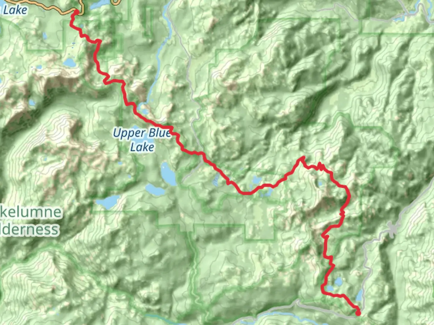
Starting your journey near Alpine County, California, the Pacific Crest Trail from Ebbetts Pass offers a captivating 45 km (approximately 28 miles) trek through the Sierra Nevada. This point-to-point trail is rated as medium difficulty, making it accessible for hikers with some experience. With an elevation gain of around 1300 meters (approximately 4265 feet), this trail promises both challenges and rewards.
Getting There
To reach the trailhead near Ebbetts Pass, you can drive along State Route 4, a scenic highway that winds through the Sierra Nevada. If you're relying on public transport, the nearest major city is South Lake Tahoe, where you can rent a car or arrange for a shuttle service to the trailhead. The pass itself is a historical route, once used by Native American tribes and later by settlers during the California Gold Rush.
Trail Highlights
As you embark on this journey, you'll traverse a diverse landscape that includes lush forests, alpine meadows, and rugged mountain terrain. The trail offers breathtaking views of the surrounding peaks and valleys, with opportunities to spot local wildlife such as mule deer, black bears, and a variety of bird species.
#### Notable Landmarks
- Noble Lake: Approximately 8 km (5 miles) into the hike, you'll encounter Noble Lake, a serene alpine lake perfect for a short rest. The lake is surrounded by wildflowers in the spring and summer, providing a picturesque backdrop for photography enthusiasts.
- Raymond Peak: As you continue, the trail skirts the base of Raymond Peak, offering panoramic views of the Sierra Nevada. This section of the trail is particularly stunning during sunrise or sunset when the light casts a golden hue over the landscape.
- Carson-Iceberg Wilderness: Around 24 km (15 miles) into the hike, you'll enter the Carson-Iceberg Wilderness, named for the Carson River and the distinctive iceberg-shaped granite formations. This area is rich in biodiversity and geological features, making it a highlight of the trail.
Navigation and Safety
Navigating the Pacific Crest Trail from Ebbetts Pass requires careful planning. It's advisable to use the HiiKER app for real-time navigation and trail updates. The trail is well-marked, but weather conditions can change rapidly, especially at higher elevations. Ensure you have adequate gear for varying temperatures and potential rain or snow.
Historical Significance
The region surrounding Ebbetts Pass is steeped in history. The pass itself was named after John Ebbetts, a 19th-century explorer who advocated for a trans-Sierra railroad. Although his vision was never realized, the pass remains a testament to the adventurous spirit of early pioneers. The trail also intersects with ancient trade routes used by Native American tribes, adding a layer of cultural significance to your hike.
Wildlife and Flora
The trail is home to a diverse array of flora and fauna. In the spring and summer months, wildflowers blanket the meadows, while towering pines and firs provide shade along the path. Keep an eye out for the elusive Sierra Nevada red fox and listen for the calls of the mountain chickadee as you make your way through this pristine wilderness.
Embarking on the Pacific Crest Trail from Ebbetts Pass is a journey through both natural beauty and historical landscapes, offering a memorable experience for those prepared to take on its challenges.

What to expect?
Activity types
Comments and Reviews
User comments, reviews and discussions about the Pacific Crest Trail from Ebbetts Pass, California.
average rating out of 5
0 rating(s)