Download
Preview
Add to list
More
6.4 km
~1 hrs 31 min
148 m
Loop
“Experience diverse landscapes and rich history on the moderately challenging 6 km Anaconda and Snake Loop Trail.”
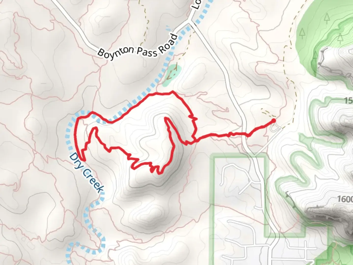
Starting near Yavapai County, Arizona, the Anaconda Trail and Snake Loop Trail offer a moderately challenging hike with a distance of around 6 km (approximately 3.7 miles) and an elevation gain of about 100 meters (328 feet). This loop trail is perfect for those looking to experience the diverse landscapes and rich history of the region.### Getting There To reach the trailhead, you can drive or use public transport. If driving, head towards the vicinity of Prescott, Arizona. The nearest significant landmark is the Prescott National Forest. For those using public transport, the closest bus stop is in downtown Prescott, from where you can take a taxi or rideshare service to the trailhead.### Trail Overview The trail begins with a gentle ascent, allowing hikers to warm up as they traverse through a mix of desert scrub and pine forest. The initial 1 km (0.6 miles) offers a gradual climb of about 30 meters (98 feet), providing a good introduction to the terrain.### Significant Landmarks and Nature As you progress, you'll encounter a variety of flora and fauna. The region is home to juniper trees, pinyon pines, and a variety of cacti. Keep an eye out for local wildlife, including mule deer, javelinas, and a variety of bird species such as the red-tailed hawk and the cactus wren.### Historical Significance Around the 2 km (1.2 miles) mark, you'll come across remnants of old mining operations. This area was historically significant during the late 19th and early 20th centuries when prospectors flocked to Arizona in search of precious minerals. The old mining shafts and equipment scattered along the trail offer a glimpse into the region's industrious past.### Mid-Trail Highlights At approximately 3 km (1.8 miles), you'll reach the highest point of the trail, with an elevation gain of around 70 meters (230 feet) from the start. This section provides panoramic views of the surrounding landscape, including the Bradshaw Mountains to the south and the Granite Dells to the north. It's an excellent spot for a rest and some photography.### Navigation and Safety The trail is well-marked, but it's always a good idea to have a reliable navigation tool. HiiKER is highly recommended for its detailed maps and real-time GPS tracking. Ensure you have enough water, especially during the hotter months, as the Arizona sun can be unforgiving.### Completing the Loop The descent begins after the 4 km (2.5 miles) mark, where the trail loops back towards the starting point. This section is relatively easier, with a gentle decline of about 30 meters (98 feet) over the next 1 km (0.6 miles). The final stretch takes you through a shaded area with more dense vegetation, providing a cool and refreshing end to your hike.### Final Stretch As you approach the end of the loop, you'll pass by a small creek, which is a great spot to cool off and enjoy the serene environment. The last 1 km (0.6 miles) is a flat and easy walk back to the trailhead, completing your 6 km (3.7 miles) journey.This trail offers a perfect blend of natural beauty, historical intrigue, and moderate physical challenge, making it a rewarding experience for hikers of all levels.

What to expect?
Activity types
Comments and Reviews
User comments, reviews and discussions about the Anaconda trail and Snake Loop Trail, Arizona.
4.64
average rating out of 5
14 rating(s)