Download
Preview
Add to list
More
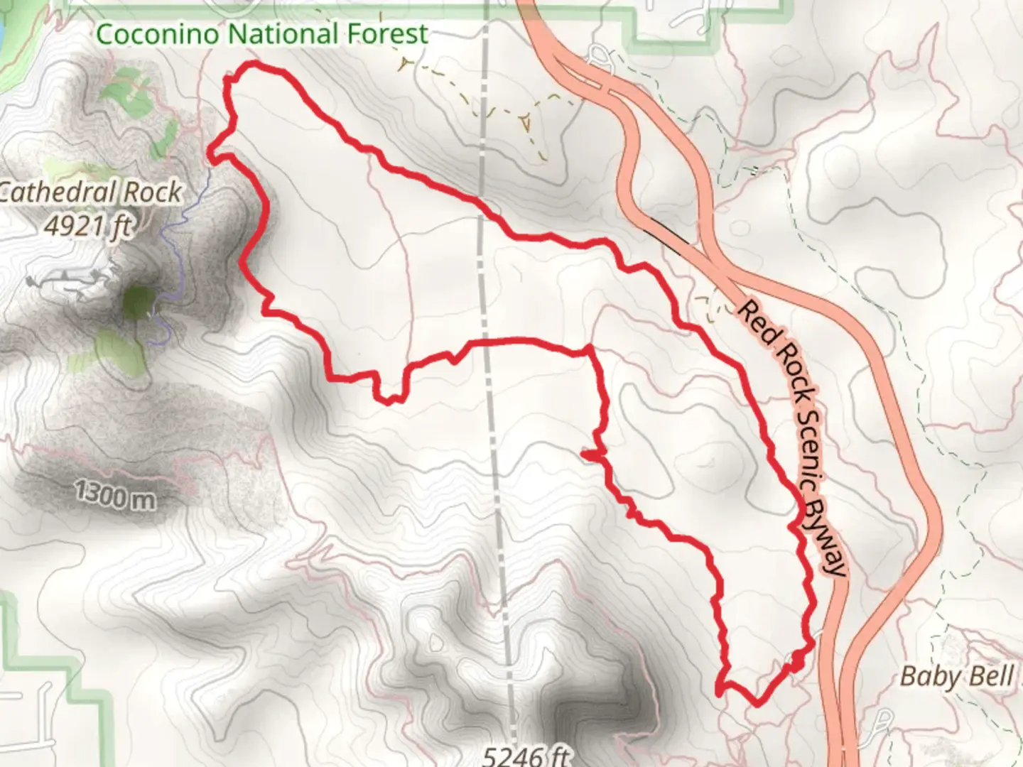
7.4 km
~2 hrs 0 min
311 m
Loop
“Embark on a captivating 7-kilometer loop through Sedona's red rock landscapes, rich in history and natural beauty.”
Starting your adventure near Coconino County, Arizona, this loop trail spans approximately 7 kilometers (around 4.3 miles) with an elevation gain of about 300 meters (984 feet). The trailhead is conveniently located near the Bell Rock Vista and Pathway parking area, making it accessible by car. If you're using public transport, the nearest significant landmark is the Village of Oak Creek, where you can catch a local shuttle or taxi to the trailhead.
Trail Overview
The Slim Shady Trail, Templeton Trail, and Easy Breezy Loop offer a diverse hiking experience through the stunning red rock landscapes of Sedona. This medium-difficulty loop is perfect for those looking to immerse themselves in the natural beauty of the area without tackling the most strenuous paths.
Slim Shady Trail
Starting from the Bell Rock Vista, the Slim Shady Trail quickly introduces you to the iconic red rock formations that Sedona is famous for. The trail meanders through juniper and pine forests, offering intermittent shade and a variety of flora. Keep an eye out for the vibrant wildflowers that bloom in the spring and early summer. This section of the trail is relatively moderate, with a gradual ascent that provides excellent views of Bell Rock and Courthouse Butte.
Templeton Trail
As you transition onto the Templeton Trail, you'll notice a slight increase in elevation. This part of the loop runs parallel to Oak Creek, offering a refreshing change of scenery with lush vegetation and the soothing sounds of flowing water. The trail also passes by Cathedral Rock, one of Sedona's most photographed landmarks. This is a great spot to take a break and soak in the views. The elevation gain here is more noticeable, but the trail remains manageable for most hikers.
Easy Breezy Trail
The final leg of your journey, the Easy Breezy Trail, lives up to its name with a more relaxed terrain. This section loops back towards the starting point, offering panoramic views of the surrounding red rock formations. The trail is well-marked and less crowded, providing a peaceful end to your hike. Along the way, you'll encounter various rock outcroppings and small canyons, adding to the trail's diverse landscape.
Navigation and Safety
For navigation, it's highly recommended to use the HiiKER app, which provides detailed maps and real-time updates. The trail is well-marked, but having a reliable navigation tool can enhance your experience and ensure you stay on track.
Historical Significance
The region around Sedona is rich in Native American history, particularly the Sinagua people who inhabited the area from around 500 AD to 1425 AD. Along the trail, you may come across ancient petroglyphs and ruins, offering a glimpse into the past. The red rocks themselves are millions of years old, formed through a combination of volcanic activity and erosion, making this hike not only a natural wonder but also a journey through geological time.
Getting There
If you're driving, head towards the Bell Rock Vista and Pathway parking area, located off Highway 179. For those relying on public transport, the Village of Oak Creek is the nearest hub. From there, local shuttles or taxis can take you directly to the trailhead.
Prepare for a hike that combines natural beauty, historical intrigue, and a moderate physical challenge. Whether you're a seasoned hiker or a curious explorer, this loop offers something for everyone.

What to expect?
Activity types
Comments and Reviews
User comments, reviews and discussions about the Slim Shady Trail, Templeton Trail and Easy Breezy Loop, Arizona.
4.3
average rating out of 5
10 rating(s)